


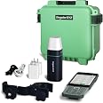
RTK GNSS Survey Equipment with Rover Handheld GPS for Surveying, Handheld Controller and Survey Software, for Construction and Geodetic or Land Survey Layout Planning
Details
- BrandSingularXYZ
- Model NameSfaira ONE
- Vehicle Service TypeBus Motorcycle
- Screen Size1 Inches
- Special FeatureBluetooth
- Map TypeWorldwide

Description
📍 Survey Smarter, Not Harder — Precision in Your Palm!
- ALL DAY ENDURANCE - 16 hours of battery life means no downtime on critical projects.
- UNMATCHED PRECISION - 1408 GNSS channels deliver centimeter-level accuracy for every survey.
- SEAMLESS CONNECTIVITY - Instant Bluetooth pairing with your phone and real-time RTK corrections via 3/4G network.
- POCKET SIZED POWERHOUSE - Compact design fits in your hand, perfect for on-the-go pros.
- VERSATILE SURVEY SOFTWARE - Supports CAD mapping, road stakeout, surface stakeout, and multiple file formats for effortless workflow integration.
The Sfaira ONE RTK GNSS Survey Equipment is a lightweight, pocket-sized rover GPS device designed for professional land, construction, and geodetic surveying. Featuring 1408 satellite channels for full-constellation tracking, it offers up to 16 hours of battery life and connects seamlessly via Bluetooth to your smartphone for real-time network RTK corrections. Preloaded with advanced survey software supporting multiple file formats and stakeout functions, it ensures high-accuracy results and efficient fieldwork. Ideal for millennial professionals seeking cutting-edge, reliable, and portable surveying technology.


Specifications
| Item Weight | 14.4 ounces |
| Product Dimensions | 1.97 x 1.97 x 5.87 inches |
| Country of Origin | China |
| Item model number | GNSS RECEIVER |
| Batteries | 1 Lithium Polymer batteries required. (included) |
| Display Size | 1 Inches |
| Warranty | 1 year |
| Battery Life | 16 Hours |
| Voice command | Touchscreen |
Have a Question? See What Others Asked
Reviews
C**N
Sfaira One is an Excellent Compact GPS Survey Rover
This is a very affordable rover headpiece that comes with a SC200 handheld controller (basically a cell phone). It works well in open areas with some tree cover, and can work in more wooded areas with some persistence. You will need to buy a SIM chip for the phone communication to your local corrections tower, and you really need to the 1.8m pole that is sold separately. The pole is very nice and worth the money they want for it. There were two aspects to the location configuration that I had to work out, the GNSS was fairly straight forward, but there is also an elevation module I needed to download for the vertical corrections. The end result was quite accurate. I was very happy with the sales and tech support, although there was some delay with them being located in China. Similar US or Euro made devices cost 5-10x more than this set up does. Had I purchased a $1500 per year local GNSS subscription from a 3rd party I'm sure my connection would have been stronger. The State's free GNSS was adequate but much farther away - over 5 miles when the 3rd party tower was less than 1km. Overall a very impressive system. I do wish the software had a detailed English manual written for it, it has a lot of customizable features that I wanted to understand better. Their tutorial videos are adequate to get started, and if I had any knowledge of modern surveying it would have been easier, but that's my fault. I really like the export to CAD option for the files.
A**N
Great value in RTK GNSS!
This little Safari RTK GNSS Rover is AWESOME! I really cannot express how functional it is to use this unit. It is small but very accurate and paired with a Carbon Fiber collapsible rod it is very light weight! The Safari and the data collector boot up fast and you get a fix quickly with a good corrections service. I really like just how compact it is and that I can use it on the fly when doing grade work. The company has very good customer support and even hooked me up with the software and license to run it on a 10" Android Tablet that I installed on my Dozer. The Safari Rover easily mounted on my dozer blade with a magnetic rod mount! The battery life is extremely good and will easily hold a charge all day. Highly recommend!
D**H
All you need to for precise GPS measurements
This is exactly what I needed to make maps. I’m a hobbyist GIS fan and I wanted a way to measure a given piece of land and make maps. I was worried that this would also require a separate base station, but this device uses a CORS network (free in NY State) and your phone or WiFi connection to get the corrections. This allows me to collect data without any other people involved.The receiver unit is solid, you’ll need to add an actual rover stick to mount the antenna. The handheld unit is very easy to use. I export data files using the Android file app to Google Drive and then pull the files out of Google Drive to my laptop.You get the CORS data in WGS84 format (you can change what gets exported) (EPSG: 4326). You can assign codes to the individual readings and then split the resulting vector file by code. An amazing amount to data is available for export.I’m really happy with this product. It wasn’t obvious to me that it would work for my personal use case, but happily the system met my needs.Note: According to SingularXYZ, this unit cannot collect the level of detail to use RINEX files if you aren’t connected to the internet. My personal workaround was to get a satellite WiFi solution. I am trying to map small lakes in the mountains without cell service.
J**2
Extremely difficult to set up
This unit is extremely difficult to set up. The manual is nearly useless. It's obviously written in Chinese and poorly translated into English. I have spent hours and hours trying to decipher what they are talking about. Almost at the end of the 30 day return window without success of setup. Really disappointed.
A**R
Rover is Excellent, Data Collector is Sketchy
I've used a ton of GNSS rovers over the years, from both large and small companies. Tilt correction is a game changer!The Safia One Plus rover is outstanding- quite light and small, seems to get good reception. The tilt calibration requires shaking the rover back and forth at each boot up, and then again if status goes from float back to fix- not a huge deal. If I'm being picky, I'd like to have the LEDs be more informative with fix status, and battery percentage. Overall very happy with this rover.The data collector on the other hand is concerning. The hardware is great, bright screen, responsive touch screen, camera with 'double press power button' shortcut, good battery life. I don't tend to use the hardware buttons as much as I thought I would, but it is nice to have them.The data collector runs Android 8.1, with a Aug 2018 security update. Initially, the SIM card didn't work, and APN options were disabled; and the SC100 did not connect to the Safia One Plus. After a factory reset, the SIM did work, and connections to the rover worked also. I think I had to re-install the survey software from the SingularXYZ dropbox site to get a version that included the Safia One Plus.The SC100 boots up with enterprise Mobile Device Management software active. This means that SingularXYZ has full access and control of the device remotely, all data on it, and can wipe it at any time. It took numerous emails with customer service to explain that this is quite problematic for surveys that will be completed for private clients on private property. Eventually they provided a code to disable the MDM software- though they would not provide root access.Also be aware that the survey software (SingularPad and SingularSurv) calls home essentially continuously. These Singular apps are adapted from a bunch of similar Chinese GNSS survey apps (SurPad,Survey Master, Nuwa, etc). Why a GNSS survey application needs a data connection to mainland China is anyone's guess, but it is something to be aware of.Not sure if any other survey apps support the tilt correction from the Safia One Plus. A demo of FieldGenius did not. So, essentially if you want to use this excellent GNSS rover, be aware of potential privacy issues.
Common Questions
Trustpilot
1 month ago
3 weeks ago
